Sunday, November 20, 2016

Jug End south to Bear Mountain

We hiked in at night.  It was about 6:30pm when we left Jug End road and began hiking up toward Jug End and eventually the Glen Brook shelter.  The sky was clear with lots of stars and for a time no moon.  We reached the first lookout on Jug End with little trouble and sat for a spell to enjoy the stars and look out over the valley.

It is about 3.5 miles to Glen Brook shelter and we kept it moving steadily.  There are some nice look out spots along this section that look east where we were able to star gaze and see the lights of the homes and cars far below us.  We arrived at our destination about 9:30pm and set up camp.  We had both hammock campers and tent campers on this trip.  Once camp was set and our food stored in the provided bear box we all turned in for the night.  The Scouts all did a great job hiking and navigating in the dark.  

The next morning dawned bright and sunny, and we were all up by 7:00am.  Breakfast was cooked and camp was struck without any fuss.  The Scouts all know just what to do and go about their camp chores with practice and efficiency.  We were back on the trail by 8:00am and heading south.


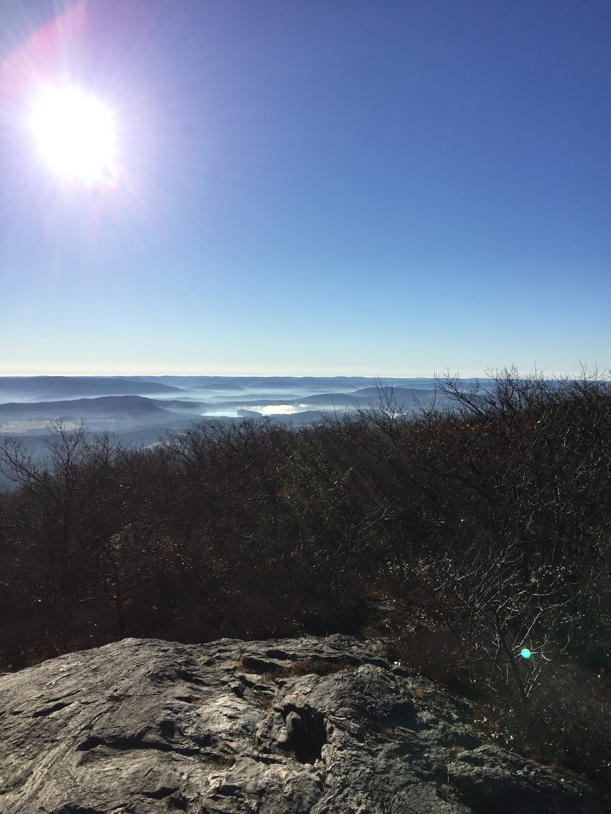
The trail starts climbing up Mt. Everett pretty soon after leaving Glen Brook shelter.  We shed some layers at the parking area for Mt. Everett Reservation and continued up.  The going is fairly smooth and soon the views are everywhere.  We all stopped to take pictures and enjoy the early morning sunshine.  Looking down into the valley you could see the fog laying in the low spots.  It was cool!


The going down Mt. Everett was slow due to all the freshly fallen leaves.  There were many slips but luckily no one fell.  Once down it was right back up, climbing Mt. Race.  We enjoyed a nice break and the 360* views from the top here as well.  It was a beautiful day, bright sunshine and warm, especially for mid-November. 


The trail goes along the ridge with a long drop only feet away.  It provides spectacular views along the way looking east into the valley and over the twin lakes in Connecticut.  We all enjoyed walking the edge.  


After leaving the ridge the trail descends through mixed hardwoods and eventually takes you through Sages Ravine.  We stopped and had lunch before making the final push into Sages Ravine and up Bear Mountain.  We crossed into Connecticut and filtered water before the climb.  The last time I hiked this with the scouts it was pouring rain at this point, so the sun and warmth was nice.  We made the climb up Bear Mt. and stopped to enjoy yet another view.  I had commitments for the next day, so needed to hike out to my car at this point.  The rest of the group continued on south toward the Riga Shelter and eventually back to route 41.  It was a nice hike on a very nice section of the Appalachian Trail and I am sure we will be back to hike it again.


Wednesday, September 14, 2016

Mt Jefferson

For the last hike of my New Hampshire trip the group decided to hike up Mt Jefferson.  We hiked up the Caps Ridge trail, a 2.5 mile trip up to the summit.  The morning was clear and crisp with temps in the mid 40's .  We started hiking at 8:30am from the trailhead on Jefferson Notch rd.  The trail begins pretty easy with a gradual climb for the first mile or so before becoming steeper.  The first views of the day were from a large rock with some interesting bowls cut out on the surface.  I stopped and took a few pictures from here before moving on and climbing out of the trees.

Looking up to where I was headed!
Once breaking out of the trees the trail climbs steeply over the "caps", a series of large rock outcroppings, and makes its way toward the summit.  It takes a little time to maneuver up and over the rocks, there are some sections where handholds and searching for just the right footing is critical.  


At the 2.1 mile mark there is a trail junction and the Caps Ridge trail makes the final .4 mile push to the top.  The views from the summit were spectacular.  We were able to see quite a distance, looking west toward Vermont, as well as much of the White Mountains spread out around us.  Mt. Washington and the rest of the Presidentials were easy to spot and I look forward to hiking up on the ridge there again.  We had a snack on the top and watched the Cog Railroad go up and down Mt. Washington for a little while before it was time to head back down.


The trip back down went smoothly, although there are some spots that take a little time get through. Careful footing is needed as you descend from rock to rock.  Once past the "caps" and down in the trees the going gets quicker and we made good time.  We couldn't have asked for better hiking weather and it was a great way to end our trip.  We arrived back at the car by 3pm and concluded our trip to the Whites.  

Loving the view!!

The trail goes down there!

Tuesday, September 13, 2016

Flume and Liberty

I made my way to New Hampshire this past weekend to hike with some friends.  It was going to be three days of peak bagging in the Whites, what could be better?  For day one we decided that we would hike Mt. Flume and Liberty by hiking up the Flume Slide trail and then down Liberty Springs trail for a nice loop hike.  We arrived at the Liberty Springs trailhead parking and began hiking by about 9:00am.  We hiked about 1.3 miles on the Whitehouse trail and Liberty Springs trail before meeting up with and taking the Flume Slide trail.  The Flume Slide starts out fairly flat and is easy going for a ways before making the steep climb to the top.

I have heard and read many accounts of how difficult and steep this trail is, and they are all correct. Once the climb starts it is very steep and difficult.


We were lucky to have dry conditions and made it to the top without incident.  Trying to go down this trial or in wet conditions would be dangerous.  It was a tough climb and we were all pretty tired when we reached the summit, but the views were great, even with all the clouds.  We enjoyed a snack and some water and recovered some of our energy.  

The clouds were getting darker so we continued on to Mt. Liberty.  This is a quick 1.5 mile hike from peak to peak, where I stopped for some pictures and continued on.


Just past the summit of Liberty the junction with the Liberty Springs trail comes up on the left and we began the descent to the parking lot.  It is a long steady decline down past the Liberty Springs tentsite and eventually back to the parking area.  The trip down is tough on the knees but is not overly steep. The rain began falling as we made our way down.  It started as a light rain and then would pick up for a brief shower before letting up again.  It made the rocks wet in areas that were exposed.  The rocks under the trees stayed dry, which helped with footing.  It never rained hard and I didn't need to break out the rain gear, but it was a preview of what was to come.  From the junction with the Franconia Ridge trail it is a little over 3 miles back to the parking lot.  It was a good loop hike that was challenging and tough but the views made it worth it.  Day 1 was in the books, we would now make our way toward Mt. Washington and the Presidentials!

Wednesday, August 10, 2016

South Taconic Trail - New Section

I hiked the new section of the South Taconic Trail yesterday.  This section is at the southern end of the trail, extending it another 6 or so miles.  I arrived at the Shagroy Rd. trailhead just before 11am, on a beautiful day for mid August.  It was sunny with low humidity and a little breeze.  Temps were to reach into the mid and upper 80's.

The trail begins by winding its way around a pond and an open grassy area before quickly entering a hardwood forest.  It then follows an dirt road for a little ways, all at a gentle climb.  Soon I reached the trail junction for Rudd Pond, where I continued on the STT.  It is a steady but easy climb to the first look out of the day.  
Nice view of the valley

Zoomed in on the Catskills in the distance
I stopped here and had a snack and some water before hiking on.  I enjoyed the varied terrain, nothing to difficult, and the different forest types as I hiked along.  On the ridge top it was Oak forest, but the trail passes through groves of Hemlock, where it is deeply shaded and quiet, then there are areas where large Sugar Maples dominate and it looks like it was farmland in the distant past.  Areas that had been logged years ago that are regenerating and are thick with saplings and new growth, it was very interesting.  After crossing Kaye Rd. it was another steady climb to the ridge, with some views.


I hiked about 4 miles in and had to turn around and hike out as I was alone and was working with some time constraints.  I was just short of the trail junction for Quarry Hill Rd. but I really enjoyed this new section and will be back again soon to finish.  I think this is a good addition to the South Taconic Trail.  I was surprised to find that some of the streams were still running with water, being almost mid August and very dry lately.  It's good to know there could be some reliable water along this section, as it gets pretty dry after South Brace Mountain.

Sunday, June 26, 2016

Blackhead Range overnight

After much planning and then re planning I headed back to the Catskills for a father/son overnight backpack with my son, Tom.  We decided to go back to the Blackhead Range and climb Blackhead, Black Dome, and Thomas Cole mountains.  The weather was beautiful, perfect for early summer hiking.
Blackhead, Black Dome, and Thomas Cole
We arrived at the DEC parking lot on Big Hollow Rd. (Country rt 56) about 3pm and planned to stay the night near the Batavia Kill shelter.  It is a quick hike in to the shelter, about 1.5 miles, and we made good time.  We hung out at the shelter for a bit before making our way up to the top of the ridge where we hung our hammocks and set up for the night. 
Tom hanging out in Batavia Kill shelter


Once camp was set up we had time to kill before dinner and we just relaxed in the hammocks and enjoyed the afternoon.  For dinner, we made the short trip back to the shelter to cook and refill our water bottles.  Mountain House Chili Mac went down good for me and Tom made a tuna wrap and then downed a Mountain House Spaghetti and Meat Sauce meal.  Both Mountain House meals were tasty and filling.  We agreed they were "keepers" and would make another trip with us in the future.  After dinner we refilled water near the shelter and made our way back to our stealth site.  It was a nice relaxing evening and we were both in the hammock before dark.  We heard a group of hikers pass by on the trail and make their way down to the shelter, and from the sounds of it set up camp there.  I was glad we opted to set up further away.

The morning dawned bright and sunny and we broke camp early, hoping to beat the afternoon heat. We ate a quick breakfast and made our way to the Escarpment Trail and began the climb up Blackhead.  From reading reports online I was expecting a steep difficult climb, and that is exactly what it was.  It is just under a mile to the summit from where we started and the climb gets steeper and more difficult the higher you go.  There is a nice lookout on the way up and other screened views as well.


Getting steep now
After the first views and as it got steeper and more technical, Tom really started to enjoy the mountains and hike.  I, on the other hand, began to run out of gas and was pretty tired by the time we reached the summit, at 3950ft.  We both loved the climb though, using both our hands and knees to get over obstacles, and the change in forest, to a Boreal forest, was awesome.  We both loved it.  We took a short break at the summit and drank and rested before exploring the top and seeing another lookout.

Camp Steel 1935


After hanging out on Blackhead for a bit we headed over to Black Dome.  The trail descends about 400 ft or so before climbing to the summit of Black Dome.  There was a great view on the way down and we stopped and took many pictures before the trees covered us again.
Looking at Black Dome


After the great views we made our way down to the trail junction in Lockwood Gap.  We decided to drop our full packs and hike Black Dome and Thomas Cole with only the cameras and water.  It made it much easier and we were glad to be rid of the weight.  The climb up Black Dome has some steep scrambles and there are a couple spots where both hands are required to make it up.  It goes pretty quick and soon you are cruising through the Boreal forest on top and the hiking is easy.  On the way up there is a lookout offering a great view of Blackhead and the valleys on both sides.  It was great and Tom enjoyed seeing the mountain he had just hiked up and over.

Climbing up Black Dome


We hiked up and over the summit of Black Dome, 3990 ft, with only one lookout.  This offered nice views looking south and west.  Hunter mountain stood out to me as we enjoyed the view.  We then started toward Thomas Cole mountain, which has no views from the summit.  Tom decided he would wait for me and I made a quick jaunt over and back to hit the summit.  Thomas Cole mountian is 3950ft  with a beautiful Boreal forest on the summit but no views out.  After reaching the summit I returned and Tom and I made our way back over Black Dome and down to Lockwood Gap to retreive our packs.

View from Black Dome
 After coming down from Black Dome we grabbed our packs and made the long descent down Lockwood Gap to the Batavia Kill and on to the car.  The trip down was long, with lots of loose rock covering the trail, making it treacherous.  Eventually the trail leveled out somewhat and the rocks were not as difficult to navigate.  We arrived back at the car at noon and headed home.  We had hiked 7 miles and climbed three of the Catskills 3500 footers.  It was a fantastic trip!